Contributors
Author: Amro Wawi, is currently working in the Netherlands as a project manager in a geo-data analytics company. A Ph.D. candidate in water data governance at the University of Twente in the Netherlands, he holds an M.Sc. in Environmental and Energy Management from the University of Twente. He worked for over five years as a consultant for startups on water and smart agriculture in Palestine, and conducted his master’s research on wastewater governance, where he gained knowledge and expertise in the water context of Palestine.
Reviewer: Fanack Water editorial team.
Introduction
Palestine is one of the most unique water cases in the world, not only for its water scarcity but also for its complex political context. Understanding the Palestinian water sector therefore requires a closer look at the political processes and factors, as well as their consequences on water management and availability. This section aims to explain the relevant topics and terms mentioned in this country file by providing a temporal perspective.
Before 1948
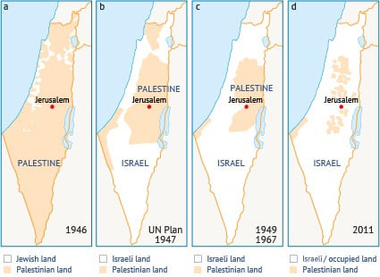
Historically, Palestine was one country, but over the past century its political system has been influenced and controlled by several countries. Consider the Ottoman Empire, which lasted until 1920, and the British mandate (1920-1948) (Map 1.a). The laws governing water and land ownership at that time were mainly adopted from Ottoman law. In November 1947, the United Nations (UN) announced Resolution 181, recommending the partition of Palestine into Israel (Jewish state) and Palestine (Arab state) (Map 1.b).
Between 1948 and 1967
After the State of Israel was established in 1947, water became central to its existence. In 1955, Israeli Prime Minister David Ben-Gurion summed up the importance of water by saying: “Today the Jews are waging a water battle, and the outcome of this battle determines our fate, and if we lose this battle, then our existence is threatened.”[1] As part of waging this battle, Israel expanded its territory over Palestinian water resources (e.g. the Jordan River, Lake Tiberias and mountain aquifers) (Map 1.c). Moreover, Israel implemented several projects to ensure that industrial, agricultural and domestic users had access to the water network. These projects were designed to meet Israel’s future water needs while ignoring Palestine’s share.[2]
Between 1967 and 1994
After the 1967 war, Israel occupied the West Bank and Gaza Strip and enforced several measures to control the water resources in the Palestinian territories, which Israel had until then not had access to. These measures included:
- Military orders establishing ownership and allocation measures (such as 92/1967, 158/1967, 291/1968, 369/1970, 457/1973 and 498/1984).[3] These orders stipulated provisions and regulations related to water, its transportation, extraction, consumption, sale and distribution, control of its use, sharing, determining quotas, establishing water installations, drilling wells, granting licenses and all matters related to water resources, including springs, ponds, streams and rivers. In addition to setting prices and quantities allowed for use by farmers, these orders made it easier for the authorities to seize and use water exclusively.
- The Israeli military government represented by the Civil Administration (CA) was designated as the authority responsible for all water-related issues in occupied Palestine.
- All water resources were declared the public property of Israel.[4] Palestinians needed a license from the CA to drill for water, determine the drill depth, construct any new water installation and even repair existing wells.
- Any water-related project, regardless of its scale, including reservoirs, networks, pipelines and so on, required a license/permit from the CA. In principle, these permits should have been granted, if only after a protracted bureaucratic process. In practice, only 13 permits were issued in the 30 years between 1967 and 1996.
1995-present
Oslo Agreement
In 1995, in an international effort to solve the long-running conflict, including water issues, Israel and the Palestine Liberation Organization (PLO) signed the Interim Agreement in Oslo. Then the Palestinian Authority (PA) was established to facilitate and regulate Palestinian issues in the West Bank and Gaza Strip. This agreement was intended to be revised within the interim period of five years.
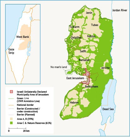
The Oslo Agreement divided the West Bank into three jurisdictions known as A, B and C. Area A is under PA administrative and security jurisdiction (excluding water issues). Area B is under mutual jurisdiction since the PA shares security control with the CA, and Area C, representing 62% of the area of the West Bank, is solely under Israeli jurisdiction (Map 2). After signing the agreement, Israel continued expanding its settlements in the West Bank, resulting in ongoing loss of Palestinian land (Map 1.d).
Joint Water Committee
Article 40.11 of the Oslo Agreement presented a new system for water-related project approvals, which was set up and implemented. All water projects are now subject to the approval of the Joint Water Committee (JWC). This has resulted in a significant increase in projects being approved compared with the previous 30 years. Of the 417 projects submitted to the JWC during the period 1996-2008, 57% were approved. However, as of the end of 2008, 143 projects were still awaiting approval and 22 had been rejected.[5]
The West Bank division has added new decision-makers. If a project in Area B or C is submitted to the JWC, JWC approval is not sufficient; the CA must also approve it before it can be implemented. However, the CA can veto JWC decisions. By the end of 2008, only 65 out of 202 well-drilling (water supply) projects had been approved by the JWC, and only 38 of these had been implemented after receiving CA approval.[5]
Ownership of water infrastructure
As a result of the military orders issued following the 1967 war, the ownership of water infrastructure in the West Bank was transferred to Mekorot, Israel’s national water company. Mekorot supplies large amounts of water to Israeli settlements in the West Bank from the Palestinian share of the West Bank’s aquifers. Currently, Israel uses approximately 85% of the West Bank’s available water resources, leaving only about 15% for Palestinians.[6] Following the signing of the Oslo Agreement, the PA became responsible for water and sewage management for Palestinians. However, the ownership of infrastructure was not addressed as the permanent status negotiations never took place.
2007 Gaza and West Bank split administration
In 2007, tensions between Hamas and Fatah, the two major political parties in Palestine, led to a civil war that ended with Hamas taking control of the Gaza Strip and Fatah the West Bank. President Mahmoud Abbas declared a state of emergency, resulting in each territory having its own government.
Furthermore, Israel imposed a blockade on the Gaza Strip. This prevented the entry of materials for repairing and developing water infrastructure and led to fuel shortages for electricity production, both of which continue to hinder the provision of water and sanitation services.[7]
Geography and climate
Geography
Palestine consists of two geographical entities known as the West Bank (including East Jerusalem) and the Gaza Strip, with areas of 5,660 km2 and 365 km2 respectively.[8] The West Bank is surrounded by Israel to the west, north and south, and by the Jordan River to the east. At the same time, Israeli settlements inside the West Bank count for 51.6% of its area.[9] The Gaza Strip is located on the eastern coast of the Mediterranean Sea. It is surrounded by Israel to the east and north and borders Egypt to the south and the Mediterranean to the west.
Palestine has several topographical and altitude variations in its small area, especially in the West Bank where the altitude varies from 1,020 metres above sea level in Hebron to 420 metres below sea level in Jericho. The Gaza Strip is a foreshore plain that gradually slopes westwards, with four ridges that range between 20-90 metres in elevation.[10]
Climate and rainfall
Palestine has a Mediterranean climate characterized by hot, dry summers between May and September and cold, rainy winters between October and April. August is the hottest month, with temperatures ranging from 18°C-38°C. January is the coldest month, with temperatures ranging from 5°C-10°C. In general, weather extremes depend on altitude and latitude.[11]
The West Bank can be classified as arid to hyper arid. Around 50% of the land receives rainfall of less than 500 millimetres per year (mm/yr). The Lower Jordan Valley in the south-east suffers the greatest aridity, receiving rainfall of less than 100 mm/yr. The remaining land is classified as semi-arid to sub-humid, with rainfall ranging between 500-800 mm/yr.[12] [13] In 2020, the highest rainfall was 898 mm in Nablus and the lowest was 152 mm in Jericho.
The Gaza Strip has a coastal climate, with rainfall between 200-500 mm/yr. The average seasonal rainfall varies between 526 mm/yr in the north (North Gaza governorate) and 280 mm/yr in the south (Rafah governorate).
Population
In 2017, the population of Palestine was 4.78 million and the annual growth rate was 2.4% see (Figure 1). The majority of people – 2.9 million – live in the West Bank (11 governorates), while the remaining 1.9 million live in the Gaza Strip (nine governorates).[14]
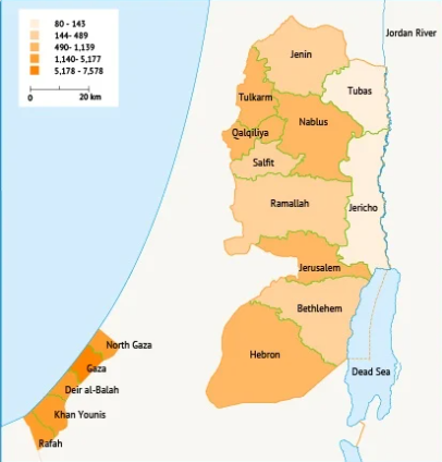
The refugee population in the West Bank is 0.87 million (19 camps) and in the Gaza Strip is 1.48 million (eight camps)[15] (Map 3). The number of settlers living in the West Bank is 0.69 million.[16] The population of Palestine is expected to reach 9.5 million in 2050 [17].
Figure 1: Palestinian population (1955-2021). Source: PCBS, 2021 [14].
Economy
The gross domestic product (GDP) increased from $2.84 billion in 1994 to $17.13 billion in 2019, whereas the GDP per capita increased from $1,201 to $3,656 between 1994 and 2019.[18]
In 2020, the impact of the COVID-19 pandemic saw the GDP drop to $15.56 billion while the GDP per capita dropped to $3,239.
As a result, unemployment rates increased to 48% in the Gaza Strip and 17% in the West Bank[19] and to 27.2% in Palestine as a whole[20].
Table 1: GDP in Palestine. Source: The World Bank, 2021, PCBS, 2021.[21]
| 2017 | 2018 | 2019 | 2020 | |
| GDP (billion $) | 16.13 | 16.28 | 17.13 | 15.56 |
| GDP per capita ($) | 3,620 | 3,562 | 3,656 | 3,239 |
| Growth rate (%) | 1.42 | 1.23 | 1.36 | -11.45 |
| Manufacturing (%) | 13 | 13.2 | 12.8 | 10.3 |
| Construction (%) | 6.5 | 5.9 | 5.6 | 4.2 |
| Agriculture (%) | 2.8 | 7.1 | 7.1 | 6.2 |
| Exports (billion $) | 15.72 | 15.96 | 15.52 | 16.04 |
| Imports (billion $) | 52.72 | 55.44 | 53.47 | 51.08 |
[1] Fares, N, 1993. ‘Water war in the Arab-Israeli conflict’. Dar Aletsam, Cairo-Egypt, p. 246.
[2] Abedalslam, A, 1990. ‘Water in Palestine’. The Palestinian Encyclopedia. Alarabia, Beirut-Lebanon, p. 253.
[3] Mansour, A and Qasife, G, 1990. ‘The economic and social conditions in the West Bank and the Gaza Strip’. The Palestinian Encyclopedia. Alarabia, Beirut-Lebanon, p. 869.
[4] Selby, J, 2013. ‘Cooperation, Domination and Colonialism: The Israeli-Palestinian Joint Water Committee’. Water Alternatives, 6(1): 1-24.
[5] The World Bank, 2009. West Bank and Gaza – Assessment of Restrictions on Palestinian Water Sector Development.
[6] PWA, 2012. Palestinian Water Sector: Status Summary Report.
[7] UNICEF, 2018. Seawater Desalination Plant for the Southern Governorates of the Gaza Strip.
[8] Palestinian Central Bureau of Statistics (PCBS), 2017. Area, population in Palestine for governorates.
[9] Vision for Political Development, 2020. The Settlement Project in the West Bank and Jerusalem.
[10] Applied Research Institute Jerusalem (ARIJ), 2015. Status of the Environment in the State of Palestine.
[11] Boavida, S et al., 2016. ‘Centralized versus Decentralized Wastewater Systems – Potential of Water Reuse within a Transboundary Context’. New Water Policy & Practice, 2: 54-75.
[12] UNDP, 2013. Palestinian Climate Change Adaptation Strategy and Programme of Action for the Palestinian Authority.
[13] Dutch Ministry of Foreign Affairs, 2018. Climate Change Profile: Palestinian Territories.
[14] PCBS, 2021. Population for Palestinian governorates.
[15] UNRWA, 2021. Where We Work – Interactive Map.
[16] PCBS, 2020. Palestine in Figures.
[17] UNFPA, 2016, Palestine 2030 Demographic Change: Opportunities for Development
[18] The World Bank, 2021. GDP per capita for Palestine.
[19] PCBS, 2021. Press Release on the Results of the Labour Force Survey First Quarter.
[20] PCBS, 2021. The Performance of the Palestinian Economy.
[21] PCBS, 2021. The Performance of the Palestinian Economy.

