The average rainfall is 3.2 billion cubic metres per year (BCM/yr). Evaporation is increasing. In 2019, it was 2,416 mm in Jericho with a 15% increment above the mean average, while in Hebron it was 2,069 mm with a 29% increment above the mean average. The annual available water quantity in Palestine is 417.9 million cubic metres (MCM).[1]
Around 289 MCM are pumped from Palestinian wells, 40.6 MCM come from spring discharge, 4.1 MCM from desalinated water and 84.2 MCM are purchased from Mekorot, Israel’s national water company (Table 1).
The exploitation of surface and groundwater from available water was 79% in 2019, putting these resources at risk if the recharge rate outstrips the abstraction rate.
Table 1: Annual available water quantity by source. Source: PCBS, 2021.[2]
| Source | Quantity (MCM) |
| Aquifers | 289 |
| Springs | 40.6 |
| Desalination | 4.1 |
| Mekorot (purchased) | 84.2 |
| Total | 417.9 |
The daily allocation per capita from consumed water for domestic purposes is 81.9 litres per capita per day (L/cap./d) – 85.6 L/cap./d in the West Bank and 77 L/cap./d in the Gaza Strip.[2]
Surface water
West Bank
Jordan River
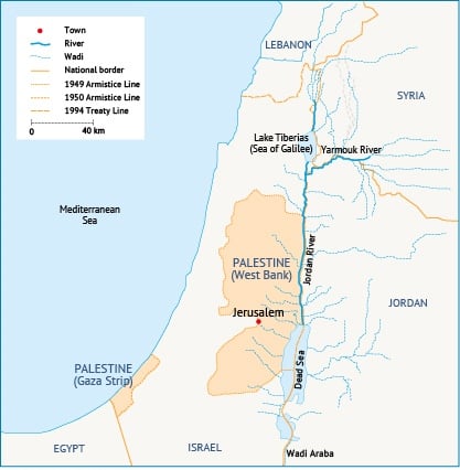
The main surface water resource in the West Bank is the Jordan River. The river has five riparians: Palestine, Israel, Jordan, Syria and Lebanon. It consists of two parts. The upper part, above Lake Tiberias, flows from the river’s headwaters (Hasbani, Banias and Leddan). The lower part flows from the south of the lake to the Dead Sea.
The river’s surface catchment area is approximately 18,300 km2, and the entire length of the river is 360 km. As the river flows southwards, water quality decreases due to the inflow of brackish water springs, untreated wastewater discharge and contaminated irrigation return flows.[3]
The river’s historical flow is estimated at 1,400 MCM/yr. However, three main factors have led to a dramatic decrease over the last seven decades to no more than 30 MCM/yr (Map 1).[4] Firstly, Israel’s National Water Carrier, a major canal, diverts more than 500 MCM of the river for irrigation use in Israel’s densely populated coastal region and the Negev desert. Secondly, the river’s natural flow was severely altered following the construction of a series of dams and diversion projects along the river and its tributaries in Israel, Jordan and Syria. Thirdly, natural factors such as evaporation and high temperatures have negatively affected river flow.
West Bank wadis
A wadi is a valley, streambed or ravine where water only flows seasonally and temporarily, often as flash floods after rainstorms. The long-term average annual flow of floodwater through wadis in the West Bank is 168.75 MCM. As shown in Map 1, based on their flow direction, the wadis are classified as either eastern wadis (toward the Jordan Valley and Dead Sea) or western wadis (towards the Mediterranean Sea). This resource is not yet exploited on a large scale. Approximately 4 MCM/yr are harvested in domestic cisterns, especially ,[5] and only 2 MCM/yr are harvested through agricultural ponds in the Jordan Valley and a small dam in Al-Auja (Table 2).
Table 2: Wadi flow rate based on direction. Source: ARIJ, 2015.
| Flow direction | Catchment | Average flow rate (MCM) |
| Western wadis flowing towards the Mediterranean Sea | AlMoqatta | 3.6 |
| AlKhodeira-Abu Nar | 8.3 | |
| AlKhodeira-Massin | 11.7 | |
| Alexander-Zeimar | 8.7 | |
| Alexandar-Abraq | 8.1 | |
| Qana | 12.8 | |
| Sarida | 22.8 | |
| Al-Dilb | 16.4 | |
| Salman | 6.5 | |
| Soreq | 2.1 | |
| Soreq Alsarar | 1.7 | |
| Lakhish-Saint | 5 | |
| Lakhish | 5.4 | |
| Shiqma | 2.6 | |
| Besor-Nar | 4.9 | |
| Besor | 2.1 | |
| Total | 122.7 | |
| Eastern wadis flowing towards the Jordan River | Malih-Shubash | 0.9 |
| Malih | 1.2 | |
| AbuSidra | 0.8 | |
| Faria | 6.4 | |
| Al-Ahmar | 4.35 | |
| Al-Auja | 4.6 | |
| Nueima | 1.7 | |
| Qilt | 4.2 | |
| Marar | 0.4 | |
| Total | 24.55 | |
| Eastern wadis flowing towards the Dead Sea | Mukallak | 3.5 |
| Qumran | 0.4 | |
| Nar | 2.4 | |
| Daraja | 5.3 | |
| Hasasa | 0.5 | |
| Ghar | 6.5 | |
| Abu Al-Hayyat | 2.4 | |
| Abu Muradin | 0.5 | |
| Total | 21.5 | |
| Total | 168.75 |
Gaza Strip
Surface water resources in the Gaza Strip are very limited. Wadi Gaza is the only surface water body in the territory. It flows from the Negev Mountains and the Southern Heights of Hebron City in the West Bank. The wadi is 105 km long. Only 9 km of this is inside Gaza, where it runs from the Armistice Line in eastern Gaza to the Mediterranean Sea.[6]
From the early 1970s, when Israel began constructing retaining dams and diversion schemes on the upper part of the wadi, the volume of water reaching Wadi Gaza was significantly reduced and had stopped completely by 2000.[6] The wadi’s annual average flow used to be about 20 MCM, but no recent information exists.[7]
Groundwater
Aquifers
Groundwater is the main freshwater resource in Palestine, accounting for 69% of its water resources.
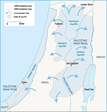
The West Bank lies above the Mountain Aquifer, which is divided into three sub-basin aquifers, namely the Western Aquifer, the North-eastern Aquifer and the Eastern Aquifer.
Meanwhile, the Gaza Strip lies above part of the Coastal Aquifer (Map 2). Winter rains replenish the groundwater aquifers with average annual recharge of 721 MCM in the West Bank.[8] The maximum recharge in the Coastal Aquifer does not exceed 60 MCM/yr.
Due to the complex political situation, water withdrawal by Palestinians in the West Bank does not exceed 14% of the potential yield from the three aquifers. In Gaza, on the other hand, 187.6 MCM were extracted from the Coastal Aquifer in 2019. This is leading to the alarming depletion of groundwater reserves, with the groundwater level in the Coastal Aquifer dropping 19 metres below sea level (Table 3).
Table 3: Recharge estimate for the main aquifers and abstraction percent. Source: PWA, 2012 and ARIJ, 2015.
| Aquifer | Catchment area (km2) | Average rainfall 2010/2011 (mm) | Recharge volume 2010/2011 (MCM) | Long-term recharge volume (MCM) | Withdrawal by Israel (%) | Withdrawal by Palestine (%) |
| Western Aquifer | 1,767 | 407 | 311 | 318-430 | 93.2 | 6.8 |
| North-eastern Aquifer | 981 | 433 | 134 | 135-187 | 83.1 | 16.9 |
| Eastern Aquifer | 2,896 | 281 | 153 | 125-197 | 73.2 | 26.8 |
| Coastal Aquifer | 365 | 225 | 33 | 55-60 |
Springs
Springs account for 10% of the water resources in the West Bank. There are around 300 springs, but most of them have a low flow rate of less than 0.1 litre per second. In 2019, the discharge was measured at 40.6 MCM, which is still lower than the average long-term discharge of 54 MCM. The most important springs in the West Bank are located within the Eastern Aquifer and are used mainly for agricultural purposes.[9]
Non-conventional sources
Desalination
Desalinated water is a renewable water resource that holds promise for arid and semi-arid regions such as Palestine. However, its potential remains untapped for several reasons, including the high cost of desalination plant installation and operation, a lack of expertise, high energy demand and the possibility of a future armed conflict destroying desalination facilities.
Desalination can be done for seawater, as in the Gaza Strip, or for brackish groundwater, as in both the Gaza Strip and Jordan Valley. In 2019, the total desalinated water quantity was 4.1 MCM. Over 150 small-capacity desalination plants operate in the Gaza Strip, around 25 of which are operated by public utilities and the rest by commercial operators. Brackish water desalination plants further deteriorate the Coastal Aquifer, Gaza’s only naturally available source of fresh water.[10]
To meet increasing water demand, UNICEF has embarked on the construction of Gaza’s largest seawater desalination plant (SDP).
Additionally, the Palestinian Water Authority (PWA) plans to implement three seawater desalination plants, with a total capacity of 35,000 m3/day (Table 4).[10]
Table 4: Seawater desalination plant (SDP) locations and capacity. Source: Union for the Mediterranean.
| SDP location | SDP capacity (m3/day) |
| North Gaza | 10,000 |
| Middle Gaza | 5,000 |
| Southern Gaza | 20,000 |
In the long term, there are plans to build the Gaza Central Desalination Plant at a cost of $621.5 million in two phases to produce a total of 110 MCM of desalinated water per year, with each phase producing 55 MCM/yr (150,000 m3/day).[11]
In the Jordan Valley, small pilot desalination projects for brackish water exist and are used mainly for agricultural purposes through the private sector. Their total capacity is less than 0.5 MCM/yr. A large facility is planned downstream of Fashka Springs, near the Dead Sea, with expected capacity of at least 22 MCM/yr by 2022.[12]
Reuse of treated wastewater
A total of 175.5 MCM of wastewater are generated annually in Palestine (95.5 MCM in the West Bank and 80 MCM in the Gaza Strip).[13] The 15 major wastewater treatment plants (WWTPs) located throughout the West Bank produce high-quality treated water, but this source is still underutilized. Some 9.5 MCM are treated yearly while less than 5% is used, primarily to irrigate fodder crops such as alfalfa and barley.[14] Since 2007, the four WWTPs in the Gaza Strip have struggled to operate because of a lack of energy, as mentioned in the first section . Current priorities should be treating wastewater and reducing pollution to the Coastal Aquifer.
Rainwater harvesting
Palestinians have been harvesting rainwater for a long time. Especially in rural areas, it is rare to find a house without at least one well that stores rainwater collected from the roof. These wells supply water for domestic use throughout the year. Palestinian researchers are working on a large-scale rainwater harvesting project that will be used to satisfy industrial and agricultural water needs, particularly in the most water-scarce locations.[15]
[1] PCBS, 2019. Water statistics in Palestine.
[2] PCBS, 2021. Press Release on the Occasion of World Water Day; on March 22th, 2021.
[3] ARIJ, 2015. Status of the Environment in the State of Palestine.
[4] Palestinian Water Authority (PWA), 2012. National Water Strategy for Palestine: Toward Building a Palestinian State from Water Perspective.
[5] ARIJ, 2015. Status of the Environment in the State of Palestine.
[6] Fattah, A et al., 2007. ‘The Avifauna of Wadi Gaza Nature Reserve, Gaza Strip – Palestine’. The Islamic University Journal 15:(1) 39-85.
[7] PWA, 2012. National Water Strategy for Palestine: Toward Building a Palestinian State from Water Perspective.
[8] Dweik, F et al., 2017. ‘Evaluation and assessment of water budget in the eastern aquifer basin of the West Bank, Palestine’. Int. J. Global Environmental Issues 16(1-3): 17-28.
[9] ARIJ, 2015. Status of the Environment in the State of Palestine.
[10] Peiris, M et al., 2019. ‘Seawater desalination transforming the Gaza Strip’. 40th WEDC International Conference, Loughborough, UK, 2017. Local Action with International Cooperation to Improve and Sustain Water, Sanitation and Hygiene Services.
[11] Union for the Mediterranean, nd. The Desalination Facility for the Gaza Strip.
[12] PWA, 2012. National Water Strategy for Palestine: Toward Building a Palestinian State from Water Perspective.
[13] Water Global Practice, 2018. Securing Water for Development in West Bank and Gaza.
[14] Wawi, A, 2017. Governance Assessment of the Wastewater Reuse Policies and Practices in Palestine: The Cases of Jenin and Nablus.
[15] Shadeed, S et al., 2020. ‘Rainwater Harvesting for Sustainable Agriculture in High Water-Poor Areas in the West Bank, Palestine’. Water 12(2): 380.


