
Sudan’s main water resources are surface water, including rainfall, rivers, seasonal wadis and khors, lakes and wetlands. Groundwater is also widely used, in addition to wastewater reuse and desalination as non-conventional resources.
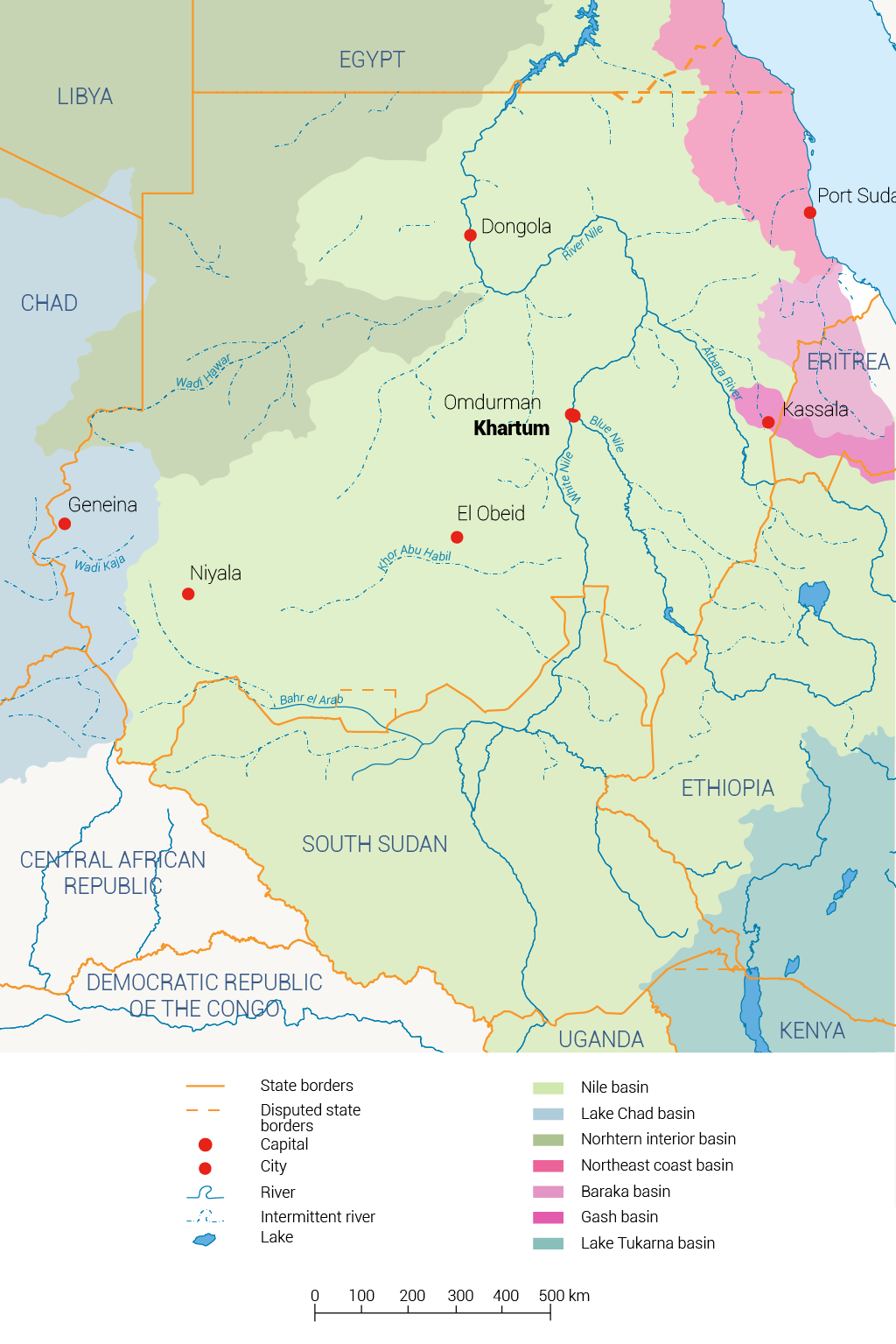
At the watershed level, Sudan comprises seven main basins as shown in Map 1. Figure 2 illustrates the percentage of each basin’s area to the total country.
Figure 1: Annual Available Surface Water in Sudan (billion cubic meter).[1]
Figure 2: Areas of Sudan’s basins (%).
Surface waters
Sudan has around one million hectares of surface water, the most important of which is a 2,000km-long stretch of the Nile and tributaries. Almost half the Nile River Basin lies within Sudan’s borders. Wetlands cover 10% of the country,[2] whereas forests cover 4%.[3] There are many seasonal water courses (khors) that run during the short rainy season. Their discharge volumes, flow durations and water quality have never been gauged. The total annual discharge of the relatively perennial rivers, outside the Nile basin, is 7.0BCM. The most important of these are the Gash, Baraka and Khor Arbaat rivers in the east, Wadi Azoom and Galol as well as many others in Darfur, and Khor Abu Habil, which drains the Nuba Mountains of Southern Kordofan.
Rainfall
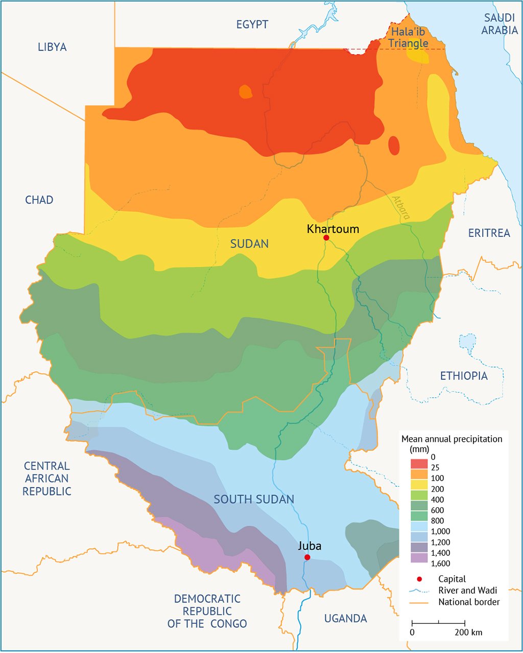
The estimated annual rainfall in Sudan is about 440 billion cubic metres. The highest rainfall rates are in southernmost parts with 800 mm/year. Precipitation decreases towards the north as the driest areas are between Khartoum, about 120 mm/year, and the border with Egypt, almost zero mm/year. The northern part is characterized by a short rainy season and scattered rainfall.[5]
Rainfall deficiency almost occurs throughout the year all over the country as evapotranspiration rates exceed rainfall. Exceptions are months of August, September and part of October. In these months, the runoff enables seasonal watercourses to run and aquifers to recharge. However, runoff water often carries silt and debris, causing erosion of the catchment area. This problem exacerbated due to increasing deforestation.[6]
Nile River
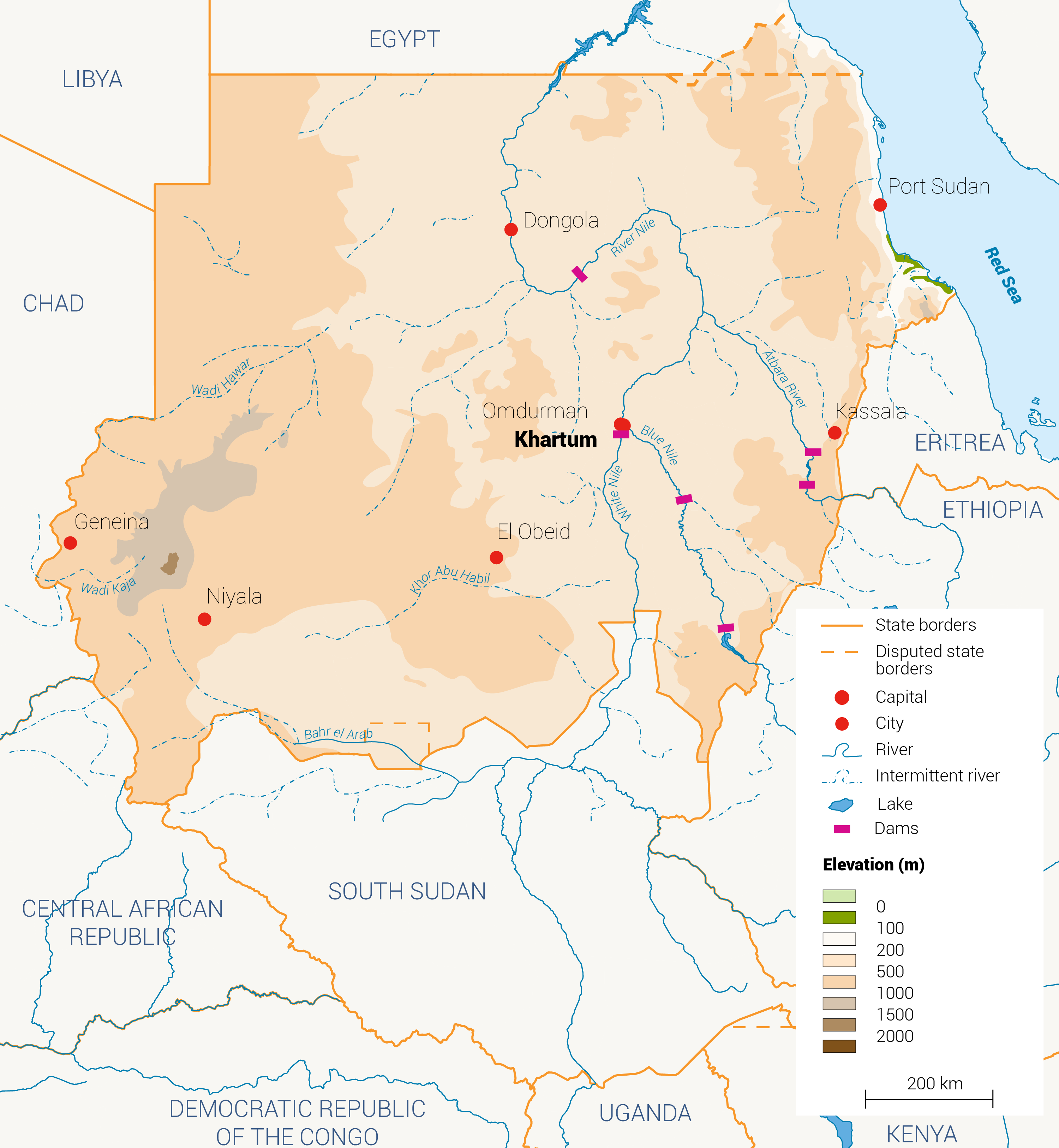
Seventy-three per cent of Sudan’s annual freshwater comes from the Nile River and its tributaries. The Nile Water Agreement of 1959 governs Sudan’s annual consumption of the Nile with 18.5 billion cubic meters out of its 80 billion cubic meters annual yield. The majority of this water is from the Blue Nile that originates in Ethiopia, passes from Sudan into Egypt. The Nile system inside Sudan includes the Blue Nile and its tributaries: the Dinder and the Rahad; the White Nile; the Atbara River and seasonal streams.[7]
Seasonal Streams
Sudan has several seasonal streams, known as wadis or khors locally. The streams flow from July to October for a few days or hours and are usually dry for the rest of the year. The biggest four streams are shared with neighbouring countries: Gash and Baraka with Eritrea, and Azum and Hawar with Chad, and others with South Sudan and the Central African Republic. Other seasonal streams in Sudan include Khor Abu Habil, Wadi El Mugaddam, Wadi Kaja, Wadi Nyala, Alawataib and Alhawad.[8]
The yield of the seasonal streams depends on the rainfall rate, and most of them are not monitored. On average, the annual flow of the seasonal streams is around 5.5 BCM.[9]
Sudan’s wetlands include:
- Freshwater lakes. Examples are Er-Rahad, Kundi, Keilak and Abyad in western Sudan. They are rich in biodiversity, especially water fowl and micro-invertebrates.[13]
- Seasonal lakes. These are found in different regions and include Butu Rayia, Um Badir, al-Fula, Ras Amir, Um Baggara, Kibbew, Undur and Nzeli.[14]
- Crater lakes. Two volcanic lakes are found in Jebel Marra (Dariba) and the Meidoub Hills (Malha). Both are saline.
- Mountain streams include Wadi Shalengo, which drains a catchment area of approximately 8,450km² on the western flank of the Nuba Mountains, and extends south-south-west through a sandstone ridge to discharge into a delta region of approximately 2,200km² around Niama. The southern edge of this delta is drained by the Regaba al-Zarga channel complex, which joins the Bahr al-Ghazal about 150 kilometres downstream of the town of Abyei. Arbaat is the only perennial stream that drains the Red Sea Hills.
Hot springs. Akasha hot springs, at the tail of Lake Nubia, are the most accessible. Others are found in Quella (Jebel Marra), al-Harra (Wadi Azum) and in the Meidoub Hills
Lakes
Sudan has several natural freshwater lakes, including Kundi in southern Darfur, Abyad in Southern Kordofan, and Turdat el-Rahad in Kordofan. Sudan also has saline lakes such as the Dariba crater in Jebel Marra in western Sudan, Malha in Northern Darfur. Beside oases such as Nikheila, Natroon and Saleema are located in the country’s north.[15]
Artificial reservoirs were also formed in the country with the construction of dams. These include Sennar and Roseires on the Blue Nile, Jebel Aulia on the White Nile, Khashm El-Girba and the Upper Atbara and Setit Complex on the River Atbara, Merowe in the Northern state, and Lake Nubia in the Northernmost of Sudan as part of the Egyptian High Aswan Dam’s reservoir.[16]
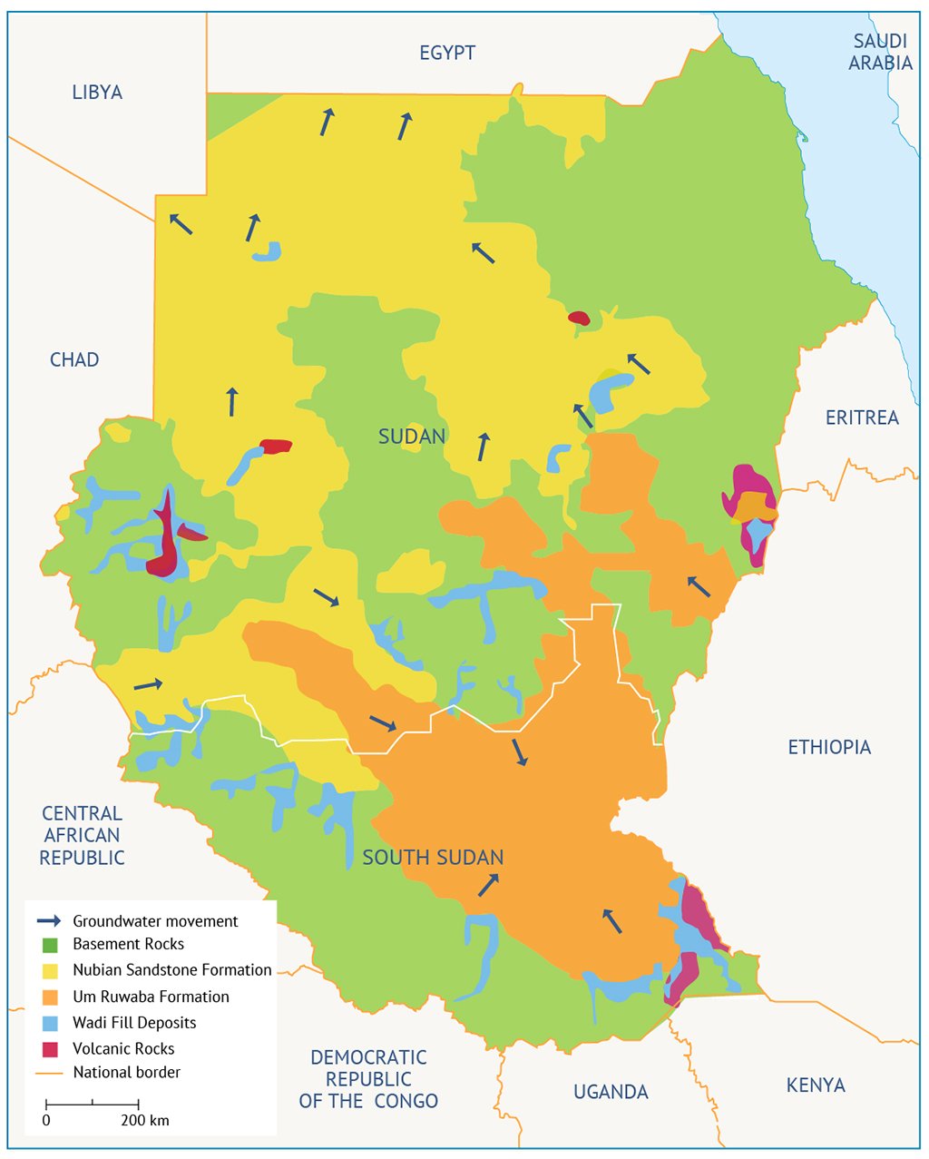
Groundwater
Groundwater is more readily available than other water resources during the long dry season. At least 80% of the population depends almost entirely on groundwater.[17] Away from the Nile basin and other non-Nilotic river wells, groundwater is the only source of water. Available groundwater is 900BCM, with an annual recharge of 1,563BCM.[18]
The Nubian Sandstone Aquifer System is shared by Sudan, Egypt and Libya. It is recharged from the Nile in Sudan (Map 3). With an area of almost 29% of Sudan, the system is the country’s most important aquifer. All the major aquifers and their annual recharge and abstractions are shown in Table 1.
Table 1: Annual recharge and abstraction from major aquifers in Sudan. [19]
| Aquifer | Storage (km3) | Annual recharge (km3) | Annual abstraction (km3) |
| Nubian sandstone | 503 | 1 | 0.7 |
| Um Ruwaba | 60 | 0.6 | 0.15 |
| Alluvial deposits | 1 | 0.375 | 0.16 |
| Total | 564 | 1.975 | 1.01 |
Non-conventional water resources
In 2020, Sudan had five desalination plants in Port Sudan that daily produced 0.02 MCM. The reuse of wastewater is limited and applied mainly in Khartoum for irrigation in the city’s suburbs.[20]
Moreover and prior to the introduction of UNICEF’s small bore hand pumps, villagers in western Sudan used to store water in the hollowed trunks of giant baobab trees (Adansonia digitata). In many other parts of the country, water is collected and stored in haffirs, a crude form of water harvesting for domestic, pastoralist and animal use in Darfur and Kordofan. There are thousands of haffirs of various storage capacities, some reaching thousands of cubic metres.
Total water availability
Sudan’s share of the water from the Nile is 20.5BCM measured at Sennar (Table 2). The non-Nilotic river provides 7BCM, with an additional 4BCM from groundwater. The Food and Agriculture Organization of the United Nations (FAO)[21] estimates the annual water withdrawal per capita to be 1,020m3.
Table 2: Overview of the available water resources in Sudan.[22]
| Water resources | Quantity (BCM) | Constraints |
| Sudan present share from the Nile water agreement (at central Sudan) | 20.5 | Seasonality, limited storage facilities, expected to be shared with riparian’s. |
| Water from wadis | 5.0 -7.0 | High variability in amounts, short duration flows, difficult to monitor or harvest, some shared with neighbors. |
| Renewable groundwater | 4.0 | Deep water, high cost of abstraction, remote areas, lack of infrastructure. |
| Present total | 30.0 | |
| Expected from reclamation of swamps | 6.0 | High capital investment social and environment problems expected. |
| Total | 36 |
[1] United Nations Environment Programme, 2020. Sudan: First State of Environment and Outlook Report 2020. Available at https://www.unep.org/resources/report/sudan-first-state-environment-outlook-report-2020
[2] Moghraby, A.I. el-, 2011. ‘Water Security After the 9th of January Referendum.’ A presentation to the Sudanese Environmental Forum.
[3] FNC, 2014. Forest National Corporation Report 9.
[5] United Nations Environment Programme, 2020. Sudan: First State of Environment and Outlook Report 2020. Available at https://www.unep.org/resources/report/sudan-first-state-environment-outlook-report-2020
[6] Ibid
[7] United Nations Environment Programme, 2020. Sudan: First State of Environment and Outlook Report 2020. Available at https://www.unep.org/resources/report/sudan-first-state-environment-outlook-report-2020
[8] Ibid
[9] Ibid
[10] UNEP, 2015. Towards a Wetlands Inventory for the Sudan. Unpublished UNEP report.
[11] Available at www.ramsar.org/wetland/sudan, accessed [19/8/2017].
[12] Van Hoven, W.K.; Tayeb, G.; Kwotel, F.T.; Ding, K.A.; Moghraby, A.I. el-, 1998. Management Plan for the Dinder National Park. UNDP Project SUD /98/G41.
[13] Green, J.; Moghraby, A.I. el-; Ali, O.M, 1984. ‘A Faunistic Reconnaissance of Lakes Kundi and Keilak, Western Sudan.’ Limnology and Marine Biology of the Sudan. Dumont, H.; Moghraby, A.I. el-; Dussougi, L.A. (eds). Springer.
[14] Moghraby, A. I. el-, 2011. ‘Water Security After the 9th of January Referendum.’ A presentation to the Sudanese Environmental Forum.
[15] United Nations Environment Programme, 2020. Sudan: First State of Environment and Outlook Report 2020. Available at https://www.unep.org/resources/report/sudan-first-state-environment-outlook-report-2020
[16] Ibid
[17] UNEP, 2015. Towards a Wetlands Inventory for the Sudan. Unpublished UNEP report.
[18] Anonymous, 2004. IGAD-HYCOS Project Document, WHTCOS No. 1.
[19] United Nations Environment Programme, 2020. Sudan: First State of Environment and Outlook Report 2020. Available at https://www.unep.org/resources/report/sudan-first-state-environment-outlook-report-2020
[20] United Nations Environment Programme, 2020. Sudan: First State of Environment and Outlook Report 2020. Available at https://www.unep.org/resources/report/sudan-first-state-environment-outlook-report-2020
[21] FAO, 2008. Recent Developments in Agricultural Research in the Sudan (SRO/SUD/623/mul).
[22] Elamin, A.W.M., 2013, Water Resources in Sudan, https://www.researchgate.net/publication/275016737_Water_Resources_in_Sudan, accessed [19/8/2017].