
About 44% of the total area of the Nile Basin lies within Sudan borders, constituting almost 75% of Sudan’s land area.[1] Sudan also shares several aquifers with neighbouring countries for the groundwater resources, such as the Nubian Sandstone Aquifer with Egypt, Libya and Chad, and the Um Ruwaba Aquifer shared with South Sudan.
The River Nile
The source of the Nile is in the Nyungwe Forest in Rwanda. From there, it travels northwards for 6,718km,[2] making it the longest river in the world. The area of the basin is 2.9 million km2 or about one tenth of the area of Africa. It is shared by 11 sovereign countries. These are Burundi, Democratic Republic of Congo, Egypt, Eritrea, Ethiopia, Kenya, Rwanda, South Sudan, Sudan, Tanzania and Uganda.
The Nile basin has astonishing geographic diversity and climatic zones. No other river in the world begins in volcanoes and mountains with glacial snows and ends in deserts. Indeed, no other major river flows northwards, traversing almost 36 degrees of latitude. However, in terms of flow volume, it rates low among the great rivers of the world. It is 2% of the Amazon, 15% of the Mississippi and 20% of the Mekong. It is comparable to the Rhine but smaller than the Zambezi, the Congo and the Niger.[3]
A salient feature of the Nile is its seasonal and annual variation in the volume of discharge. More than 80% of the annual flow occurs from August to October, and only about 20% occurs during the remaining nine months.[4] The seasonal flood is regular, but its volume has always been irregular and unpredictable. The annual discharge can be as low as 41BCM, as in 1913/1914, or as high as 141BCM, as in 1988. As shown in Table 1 and Map 1, the Nile has five sub-basins: the equatorial lakes, Bahr al-Ghazal, Sobat River, the Blue Nile and Atbara River.
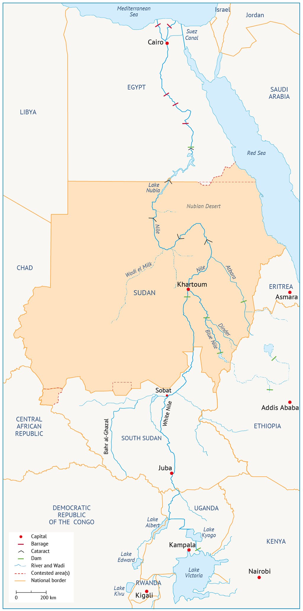
Table 1: Discharges of the Sub-Basins of the River Nile (BCM)[5]
| River | Annual average discharge | Average maximum monthly discharge | Average minimum monthly discharge |
| Blue Nile | 50.7 | 15.6 | 0.3 |
| White Nile (at Khartoum) | 27.8 | 1.4 | 1.2 |
| Atbara | 12.1 | 5.6 | 0.1 |
| Sobat | 13.1 | 2.0 | 0.3 |
| Bahr el-Jebel | 29.3 | 3.0 | 1.9 |
| River Nile (at Aswan) | 86.4 | 21.8 | 1.9 |
| Rahad | 1.06 | ||
| Dindir | 3.05 |
Treaties and agreements
In 1929, an agreement was made between the Nile basin countries, nearly all of which were under British rule. Thirty years later came the 1959 Nile Water Agreement between Egypt and Sudan, which excluded the other basin countries. Its salient stipulations are that:
• Both countries will uphold their position on ‘acquired rights’ of the allotted shares of water;
• Benefits of the envisaged control project will be divided equally between the two countries;
• Projects will be developed for saving the lost waters in the Nile basin;
• Technical cooperation will be strengthened.
Launched in February 1999, the Nile Basin Initiative provided hope for basin-wide cooperation, although it excluded Eritrea. It should have evolved into the Cooperative Framework Agreement and eventually the Nile Basin Commission. However, Egypt and Sudan were firmly against it. South Sudan’s stance is not clear.[10]
[1] FAO, 2017. AQUASTAT Information System on Water and Agriculture. Sudan Country Profile.
[2] Dumont, H.J. (ed.), 2009. The Nile: Origin, Environments, Limnology and Human Use. Springer.
[3] Hammad, S.A., 2010. The Utilization of the Nile Waters. A Shift from Position to Interests. Sudanese Ministry of Irrigation.
[4] Ibrahim, A.M., 1984. ‘The Nile: Description, hydrology, control and utilization.’ Limnology and Marine Biology of the Sudan. Dumont, H.J.; Moghraby, A.I. el-; Desugi, L.A (eds). Springer.
[5] Ibid.
[6] Collins, R., 2002. The Nile. Yale University Press.
[7] Blackmore, D.; Whittington, D., 2008. Opportunities for Cooperative Water Resources Development on the Eastern Nile: Risks and Rewards. An Independent Report of the Scoping Study Team to the Eastern Nile Council of Ministers.
[8] Verhoeven, H., 2012. Water, Civilization and Power: Sudan’s Hydropolitical Economy and Al-Ingaz Revolution. Unpublished PhD thesis. Oxford University.
[9] Song, J.; Whittington, D., 2004. ‘Why Have Some Countries on International Rivers Been Successful Negotiating Treaties? A Global Perspective.’ Water Resources Research, 40:1-18.
[10] Salman, M.A., 2010. ‘Downstream Countries Can Also Harm Upstream Riparians: The Concept of Foreclosure of Future Issues.’ Water International, 35(4): 350-364.