According to a 2014 study by the United Nation Development Programme (UNDP), annual precipitation ranges between 7.8 (dry year) and 11.9 (wet year) billion cubic metres (BCM), of which between 4.1 BCM and 6.6 BCM is groundwater recharge. The updated National Water Sector Strategy (NWSS), released in 2020, was based on the same numbers included in the 2010 strategy, which in turn were based on 2008 AQUASTAT figures from the Food and Agriculture Organization of the United Nations (FAO), namely total precipitation equivalent to 8.6 BCM. In both the NWSS 2010 and 2020, evapotranspiration is estimated to be around 50% while the Ministry of Energy and Water and the UNDP study estimated it to range between 16% and 26%.[1] This discrepancy in the data eventually leads to differences in the estimation of the groundwater recharge, highlighting one of the central challenges facing the water sector and the management of water resources: the lack of a unified database with long-term, high-quality meteorological and hydrological data sets.
Surface water (main rivers; availability since 1950)
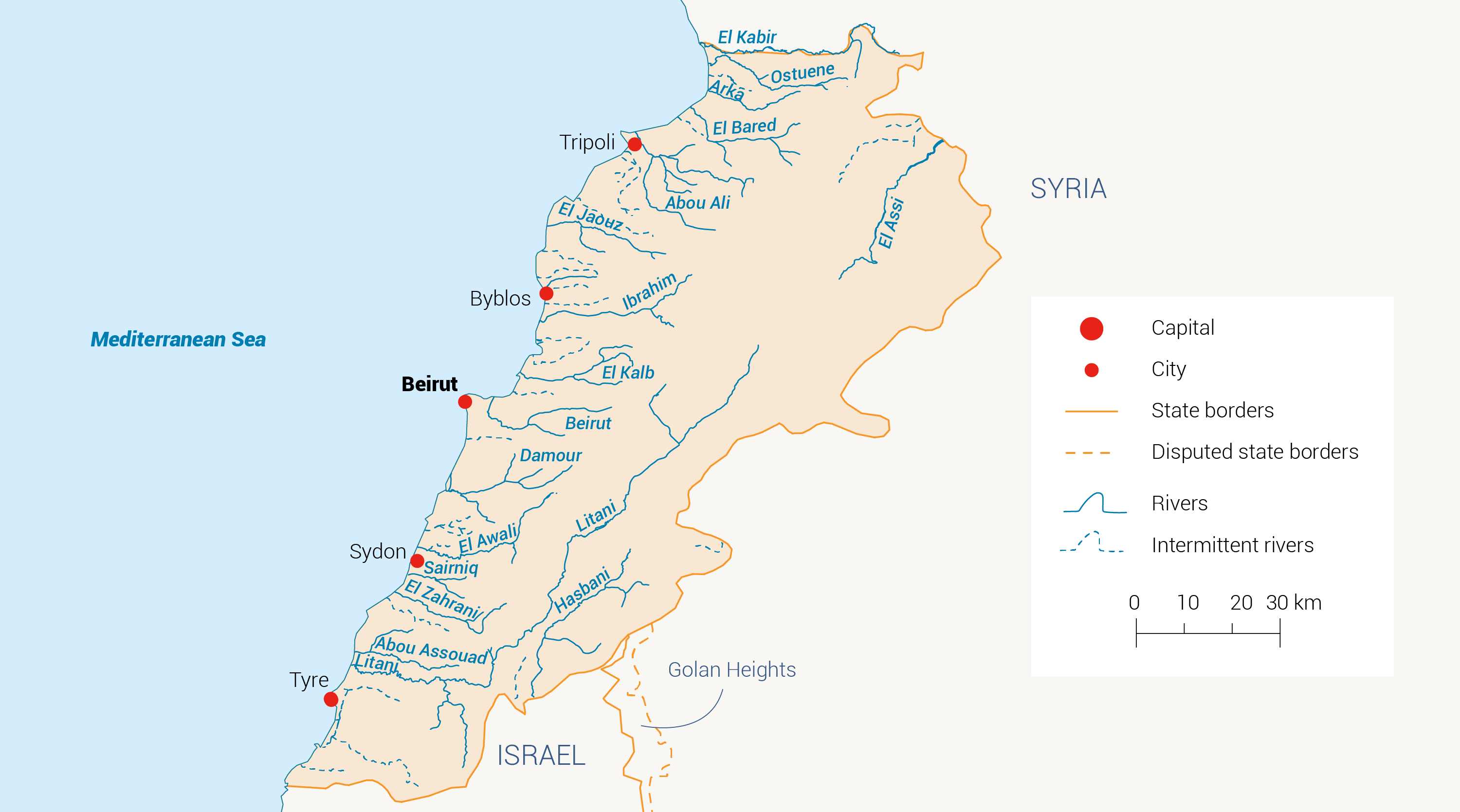
Lebanon has 40 rivers, of which 16 are considered perennial (map 1). The total combined annual river flow is estimated to be between 2,151 million cubic metres (MCM) and 3,900 MCM, with most of the flow (75%) occurring from January to May, based on data from 2010.[2] Five different hydrological zones define the hydrographic system. These are described below.
- The Litani River is the longest river in Lebanon (170 km) and has a basin area of around 2,180 km2. The river flows from the Bekaa Valley southwards, makes a 90-degree turn and continues westwards before draining into the Mediterranean Sea. The river’s annual flow is estimated at 475 MCM but is characterized by large inter-annual variations.
- The Asi River is located in the north-east of the country, flows into Syria and discharges into the Mediterranean Sea in Turkey.
- The Hasbani and Wazzani rivers, located in south-eastern Lebanon, form one of the main tributaries of the Jordan River and discharge into the Dead Sea.
- The coastal river basins, which include the remaining 12 perennial rivers as shown in map 1.
- Finally, the small, isolated sub-catchments and streams that drain between the major river basins.
Groundwater (main aquifers/springs; availability since 1950)
The precipitation rate and exposed geological formation with major karstic features and fractures (Figure 4) make the hydro-stratigraphic setting in Lebanon a special one, namely the fact that groundwater is a principal and renewable water source.
The two major groundwater aquifers, the Jurassic (J4) and Cretaceous (C4-C5), are mainly composed of karstic limestone and have an exposed area of around 5,600 km2 within Lebanon.[1] These two aquifers are regarded as the country’s water towers. However, other semi-aquifers are present and have local importance. In total, 51 groundwater basins have been identified, of which six are unproductive aquifers (mainly due to the geological formation) and 45 are productive aquifers (28 in the Mediterranean province and 17 in the interior province).
That being said, groundwater constitutes almost 50% of the water supply. This has impacted groundwater management and quality. Public wells extracting groundwater number around 1,325, of which 943 are operational. It has also been reported that around 46% of the wells tap into undefined aquifers, 33% tap into the Sannine-Maameltain aquifer (C4-C5) and 9% tap into the Kesrouane Jurassic aquifer (J4). The volume of water extracted from public wells is estimated to be 270 MCM per year.[2]
As for private wells, the number of wells registered at the Ministry of Energy and Water was 20,537 in 2012 (this number was not updated in the NWSS 2020). The number of illegal wells is thought to be three times the number of legal wells, reaching 55,000-60,000. Although the volume extracted from groundwater resources via public and private wells is estimated at around 700 MCM, this number is actually almost impossible to estimate because of the various uncertainties, including the number of wells.[1]
Due to Lebanon’s geological setting, around 5,000 springs have been identified and shown on topographic maps. However, only 409 springs have documented flow data and only nine are regularly monitored for water quality and quantity (i.e. flow). This fact makes it very difficult to estimate the springs’ total yield, although some estimates put this at between 1,200 MCM in the winter/spring and 200 MCM in the summer.[2] It is estimated that around 413 MCM are extracted from the springs mainly for domestic use.
Non-conventional sources (desalination; wastewater reuse; rainwater harvesting)
Non-conventional water resources in Lebanon remain largely untapped despite the urgent need to explore them. Recent studies show that only 8% of all the generated wastewater is treated.[2] Alternative water resource and augmentation options that have been proposed range from managed aquifer recharge and rainwater harvesting to desalination and wastewater reuse. Several pilot studies were conducted on a local scale for these options. However, they did not receive the national attention needed to promote them as an alternative to conventional sources.
Total water availability and per capita availability
The data regarding total water availability in Lebanon includes a lot of uncertainty, and questions have been raised around the use of this data. Data from different sources is shown in Table 1. The NWSS 2020 adopted the same numbers included in the NWSS 2010 and is based on readings that do not expect any change in precipitation.[5]
| Precipitation | Recharge to groundwater | Runoff | Evapotranspiration | |||||
| Reference | BCM | % | BCM | % | BCM | % | BCM | % |
| UNDP 2014- Dry year (2010-2011) | 7.8 | 100 | 4.1 | 53 | 2.1 | 27 | 1.5 | 20 |
| UNDP 2014- Wet year (2011-2012) | 11.9 | 100 | 6.6 | 56 | 3.8 | 32 | 1.4 | 12 |
| FAO | 8.6 | 100 | 3.2(i) | 37.2 | 4.1(i) | 47.6 | 1.2 | 14 |
| UNDP 1970 | 9.3 | 100 | 3.2 | 35 | 1.09 | 12 | 5.04 | 54(ii) |
| NWSS 2020 | 8.6 | 100 | 1.2(ii) | 14 | 2.9(iv) | 34 | 4.5 | 52 |
Table 1: Distribution of different estimates of water availability from different studies. [1] [2] [6]
(i) 2.5 BCM constitutes the river base flow (groundwater contribution to surface runoff).
(ii) Losses reported by the UNDP in 1970 include not only real evapotranspiration but also extraction wells and return flows (from domestic and irrigation use).
(iii) Includes losses to groundwater (700 MCM) and renewable groundwater resources (500 MCM).
(iv) Includes transboundary river flow (700 MCM) and renewable surface water resources (2,200 MCM).
The available renewable water resources in Lebanon have dropped below the water stress threshold of 1,000 m3 per capita per year (cap./yr). The NWSS 2010 estimated the total renewable resources per capita per year at 926 m3/cap./yr and expected this to continue to drop, reaching around 839 m3/cap./yr by 2015.[6] However, since then, several factors such as population growth, climate variability and the influx of refugees and displaced people have put extra strain on the available resources. The latest data from 2017 puts water availability at around 704 m3/cap./yr.[7] In addition to the challenges related to guaranteeing that water sources are sufficiently managed to meet the demands of different sectors, pollution levels in many freshwater systems have made meeting water users’ demands hard or requiring expensive treatment prior to use.
[1] UNDP (United Nations Development Programme), 2014. Assessment of Groundwater Resources of Lebanon.
[2] MoE (Ministry of Environment), 2020. Lebanon State of the Environment and Future Outlook: Turning the Crises into Opportunities (SoER 2020). With UNHCR, UNICEF and UNDP.
[3] Ina, A, n.d. Keserwan, Faqra, karst rock formations, love them. Pinterest.
[4] Shaban, A and Darwish, T, 2011. ‘The role of sinkholes in groundwater recharge in the high mountains of Lebanon.’ Journal of Environmental Hydrology 19:1-11.
[5] Eid-Sabbagh, K and Ray, A, 2021. Breaking Point: The Collapse of Lebanon’s Water Sector. Policy Paper. Triangle.
[6] MoEW (Ministry of Energy and Water), 2010. National Water Sector Strategy.
[7] The World Bank Data, n.d. Renewable internal freshwater resources per capita (cubic meters – Lebanon.

