Contributors
Co-author 1: Saleh A. Sadeg, Associate Professor in Geological Engineering Department, Faculty of Engineering, University of Tripoli, Libya; member of the Libyan Water, Energy and Food NEXUS and H2020 Libya groups.
Co-author 2: Khalil Ibrahim Al-Samarrai, Lecturer in Geological Engineering Department, Faculty of Engineering, University of Tripoli, Libya.
Reviewer: Salem Rashrash, Associate Professor in Geological Engineering Department, Faculty of Engineering, University of Tripoli; active water resources researcher, supervising research on the environmental impacts of groundwater extraction in Libya.
Libya one of several countries in the Middle East and North Africa facing high water stress, mainly because of its semi-arid to arid climate and low rainfall. Water resources in Libya rely heavily on groundwater (about 97% of the total water consumption).
Sustainable development in the country is being affected by the lack of renewable water resources as well as fossil groundwater overexploitation to meet water increasing demand. Other challenges include seawater intrusion, deteriorating water quality and an inadequate institutional framework. These and other issues related to energy and food need more attention if the United Nation’s Sustainable Development Goals (SDGs) are to be met by 2030.
Geography and climate
Situated in North Africa, Libya has a total area of 1,674,577 km2. It is bordered by the Mediterranean Sea to the north, by Egypt to the east, Sudan, Chad and Niger to the south and Tunisia and Algeria to the west (Map 1).
The most outstanding natural features are the Sahara desert and Mediterranean coast.[1] Generally, Libya’s topography slopes gently towards the north. The mountains, which are located in the north-western and north-eastern as well as southern and central parts of the country, are of low to medium latitude.[2] The only highlands are near the border with Chad, where the Tibesti Massif rises to over 2,200 metres.[3]
")
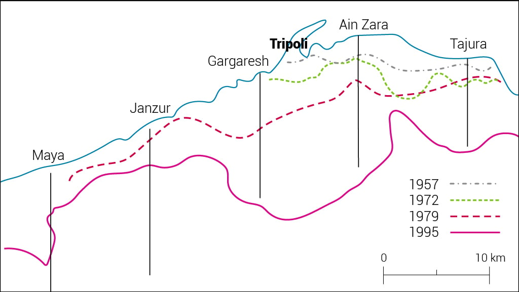
Only the coastal zone, which makes up 2% of the surface area, is considered suitable for agricultural activities. The fertile lands of the Gefara Plain in the north-west and Jabal al-Akhdar in the north-east account for more than 80% of agricultural food production, which is mostly dependent upon rainfall and groundwater. The remaining area is made up of gravel or sand dunes, mountains or sabkhas (salt marshes) with some scattered oases (Map 2).
The climate varies but is strongly influenced by the Sahara to the southand the Mediterranean to the north. The lack of natural barriers results in a gradual transition from one climate to another.[4] Accordingly, three climatic zones can be distinguished:
1. In the coastal lowlands, the climate is Mediterranean, with warm summers and mild winters.
2. The Jabal Nafusa and Jabal al-Akhdar highlands experience a plateau climate, with higher rainfall levels and low winter temperatures.
3. Moving southwards to the interior, semi-desert and desert climate conditions predominate, with stifling temperatures and large daily thermal amplitudes. Rain is rare, irregular and diminishes gradually towards zero in the far south.

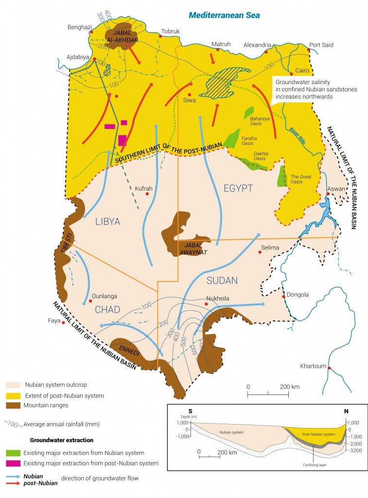
The average annual rainfall varies between zones, according to the geographic location and topography (Map 3). In general, rainfall in the north ranges between 100 and 500 millimetres per year (mm/yr), whereas the south receives as little as 10 mm/yr. Some areas such as Kufra and Murzuq receive no rain at all.[5]
")
All climatic zones experience temperature variations. In the summer, temperatures exceed 40 degrees Celsius, whereas in the winter they may fall below zero. Snow is occasionally seen on the northern hills and mountains, especially those in the east.[6]
Population
The last census in 2006 put the population of Libya at 5.32 million (Figure 1). According to the UN World Population Prospects, this number had risen to 6.87 million by June 2020.[7]It is expected to reach 9 million by 2030,[8] putting additional pressure on resources, especially food, water and energy.
The majority of the population lives along the Mediterranean coast, with a large proportion in the main cities of Tripoli and Benghazi.
Life expectancy increased from 62.2 years in the 1980s to 72.8 years in the past decade. Child mortality is low.
Figure1: Population in Libya (1964-2006).[9]
Economy
Libya’s economy could be described as agriculture-based until the early 1960s, when agriculture accounted forabout 30% of the gross domestic product (GDP). This contribution had fallen to 2% by 2007, whereas oil contributed 71% of GDP. The economy is now reliant on oil, and the performance of the agricultural sector has continued to decline, in part because of annual policy changes and the withdrawal of subsidies.[10] [11]
The government’s main economic policies are currently focused on renewing state governance, rebuilding infrastructure and restoring public services, improving economic institutions through reforming the subsidy system, rightsizing the public sector, reforming the tax system and consolidating the financial sector.[12]
More detailed information about the Libyan economy by sector is shown in Table 1.
Table 1: Libya’s economy.[13]
| GDP - real growth rate | GDP - per capita (PPP) | GDP- composition, by sector of origin |
| 64% (2017 est.) | $9,600 (2017 est.) | Agriculture: 1.3% (2017 est.) |
| -7.4% (2016 est.) | $5,900 (2016 est.) | Industry:52.3% (2017 est.) |
| -13% (2015 est.) | $6,500 (2015 est.) | Services:46.4% (2017 est.) |
| Note: data is in 2017 dollars |
[1] General Water Authority , 2014 , Water and Energy for Life in Libya (WELL) , Project funded by the European Commission No. 295143, FP7, Libya.
[2] CEDARE, 2014. Libya Water Sector M&E Rapid Assessment Report. Monitoring and Evaluation for Water in North Africa (MEWINA) project, Water Resources Management Program, CEDARE.
[3] General Water Authority , 2014 , Water and Energy for Life in Libya (WELL) , Project funded by the European Commission No. 295143, FP7, Libya.
[4] CEDARE, 2014. Libya Water Sector M&E Rapid Assessment Report. Monitoring and Evaluation for Water in North Africa (MEWINA) project, Water Resources Management Program, CEDARE.
[5] Ibid.
[6] General Water Authority , 2014 , Water and Energy for Life in Libya (WELL) , Project funded by the European Commission No. 295143, FP7, Libya.
[7] World Population Review, 2020.Libya population live.
[8] GEA, 2008. National Strategy for Sustainable Development. General Environmental Authority (GEA). Libya.
[9] Ibid.
[10] Abdudayem A., and Scott A, 2014.Water infrastructure in Libya and the water situation inagriculture in the Jefara region of Libya. African J. Economic and Sustainable Development 3(1):33-64.
[11] Allafi A. Khaled , 2014. The Impact of Changing Agricultural Policies on Libyan Agricultural Performance. Doctoral, Sheffield Hallam University.
[12] World Bank, 2020.Poverty & Equity and Macroeconomics, Trade & Investment Global Practices.
[13] Central Intelligence Agency of the United States, 2016.The World Factbook, Libya Country Profile.